Khyber Pakhtunkhaw (KPK) provincial government in Pakistan, govern by the Pakistan Tehreek-e-Insaf (PTI) party launched a reforestation program named “Billion tree Tsunami”, in 2015 (@btap2015). Imran Khan (@ImranKhanPTI), a cricket super star turned politician is the head of PTI party, Prime Minister of Pakistan and main driver behind this massive plantation campaign to turn degraded into forested land. The important aspect of this project is to monitor and identify the growth of these plantation regions. The remote sensing and Geographic Information Systems (GIS) tools provides this near-real-time (NRT) information at low cost compared to field campaigns.
The well known method to identify and monitor land surface changes using satellite remote sensing data utilizes a combination of band thresholding and optical indices (such as Normalized Difference Vegetation Index – NDVI) to separate land surface features. Applying this approach to two separate images by a given period of time allows changes in the extent of the area of interest to be identified. The atmospheric correction to the two images separated over time, extent of land can be compared. allowing for changes to be identified. this approach will provide an excellent alternative to field level change detection methods in challenging environments across Pakistan. We tested this approach for Bannu forest region (as shown in the Figure 2). The Figure 1 shows the land cover map of Bannu region for the year 2015.
 Figure 1: Land Cover map of Bannu forest region (credit to ESA CCI)
 Figure 2: Map of Bannu forest region (credit to Billion Tree Tsunami website)
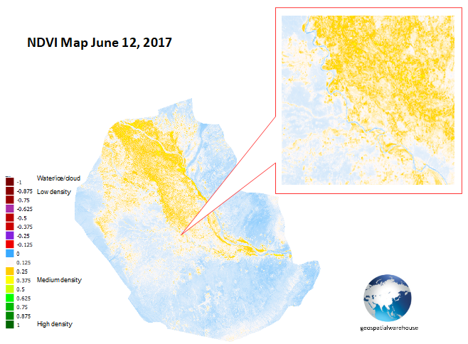
Two Landsat 8 images are used for this study area acquired in June 01, 2013 and June 12, 2017. The Landsat 8 images are freely available from the United States Geological Survey (USGS) “EarthExplorer” (https://earthexplorer.usgs.gov/). The images were converted into surface reflectance before NDVI calculations using a standardised approach ( for detail check http://landsat.usgs.gov/CDR_LSR.php).
Figure 3: NDVI map of Bannu forest region derived from Landsat 8 image acquired on June 01, 2013. 
Figure 4: NDVI map of Bannu forest region derived from Landsat 8 image acquired on June 12, 2017.
Figure 5: NDVI map in KMZ format of Bannu forest region derived from Landsat 8 image acquired on June 01, 2013 shown in google earth.
Figure 6: NDVI map in KMZ format of Bannu forest region derived from Landsat 8 image acquired on June 12, 2017 shown in google earth.
Please contact me for more detail. email: kshahidk@gmail.com twitter: @kshahidkOttawa


